RedClearTM
Battlefield Intelligence, Delivered in Seconds
Drag the slider to see the transformation
RedClear is an AI-powered platform built for the intelligence professionals responsible for IPOE and IPB. It ingests sensor observations and assessments from across the battlefield and outputs a clear, unified operating picture with enemy formations identified, classified, and ready for action.
Request a DemoThe Challenge
IPOE Shouldn't Take Hours
Intelligence Preparation of the Operational Environment is the foundation of every military operation. Today, analysts spend hours manually correlating sensor data, identifying enemy positions, and building assessments in spreadsheets and slide decks. By the time a briefing is delivered, the battlefield has already changed.
RedClear automates the process, from raw feeds to finished assessment, so analysts can focus on decision-making instead of data wrangling.
How It Works
From Sensor Feed to Unified Picture
Multi-Source Data Fusion
RedClear ingests feeds from drones, satellites, radar, ground sensors, and existing intelligence systems. All sources are fused into a single data layer regardless of format or origin.
AI-Powered Classification and Clustering
Our proprietary algorithms apply machine learning to classify equipment, identify enemy formations, and reconstruct Order of Battle using real military doctrine to determine unit types and echelons.
Decision-Ready Output
The result is a unified operating picture with enemy positions, unit types, movement patterns, and force composition clearly labeled. Analysts receive a finished assessment, not a wall of data.
Sea of Red Elimination
Multi-Echelon Aggregation
RedClear transforms hundreds of individual equipment symbols into meaningful unit-level representations. Analysts can toggle between echelon views to see the battlefield at the level of detail they need.
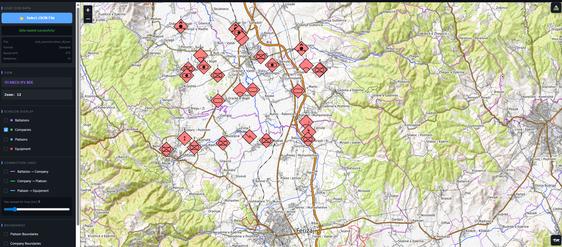
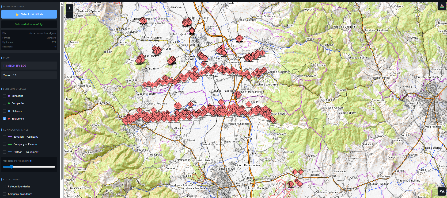
Equipment Level
875 individual equipment symbols. The "Sea of Red" that analysts struggle to interpret.
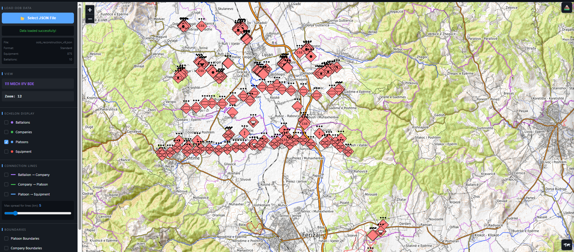
Platoon Level
Equipment grouped into platoon-sized units with boundaries and platoon-level symbols.
Company Level
Platoons grouped into companies. A higher-level view of force disposition begins to emerge.
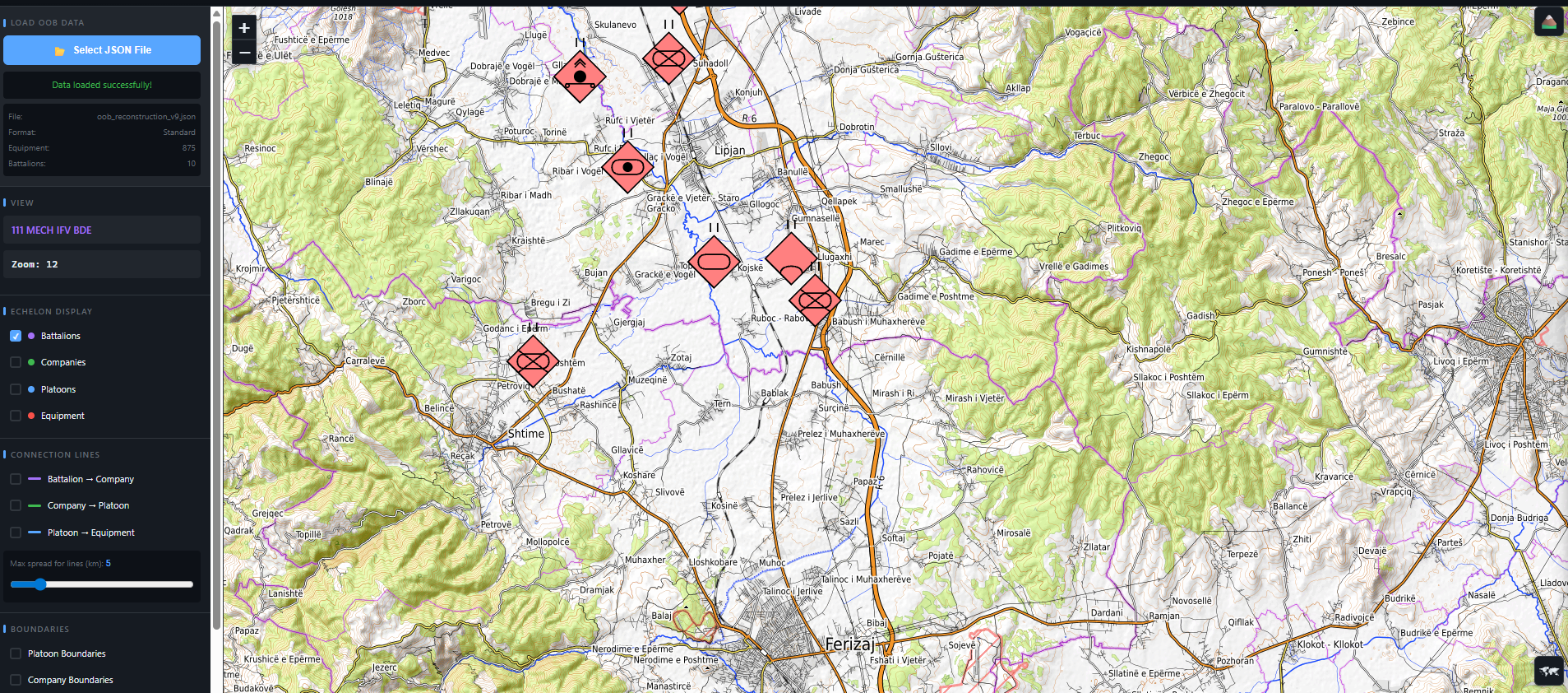
Battalion Level
The complete picture. Companies grouped into battalions showing overall enemy force structure.
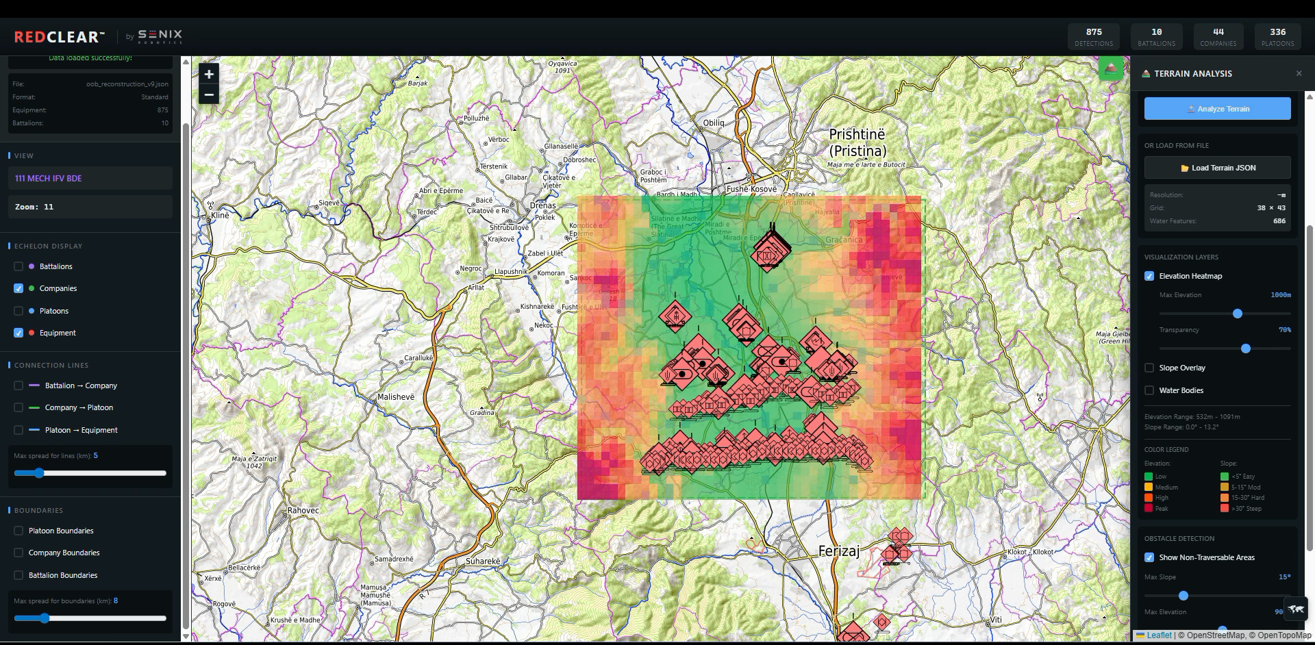
Key Feature
Terrain-Aware Center of Mass
RedClear calculates Center of Mass positions for reconstructed units at every echelon, incorporating terrain data to ensure positions are tactically realistic. A COM will never be placed in the middle of a lake or on an impassable ridge.
Elevation Integration
Incorporates digital elevation data to understand three-dimensional terrain and adjust COM positions accordingly.
Terrain Gradient Analysis
Identifies impassable slopes and restricted areas for different vehicle types. Heavy armor cannot traverse steep slopes.
Restricted Area Exclusion
Bodies of water, minefields, urban rubble, and severely restricted terrain are automatically excluded from COM placement.
Formation Analysis
Detects formation orientation, dimensions, frontage, spacing, and classifies offensive vs. defensive postures.
Key Feature
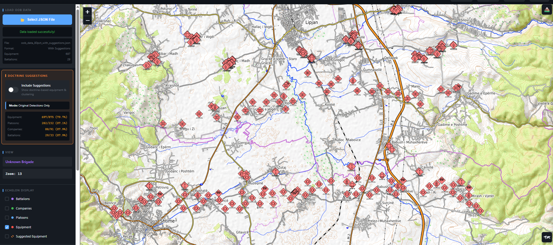
Known Unknown Methodology
Sensors rarely detect all enemy equipment. RedClear systematically identifies gaps in sensor coverage, determines what is missing based on doctrinal unit composition, and recommends likely locations for undetected equipment.
Gap Detection
Compares detected equipment against doctrinal composition patterns to identify what should be present but was not detected by sensors.
Location Recommendation
Recommends likely positions for missing equipment based on doctrinal positioning, terrain suitability, and proximity to related detected equipment.
Analyst-Controlled
Suggested equipment is visually differentiated with dashed lines. Analysts review each suggestion and decide whether to approve inclusion. Nothing is automatic.
Missing equipment displayed with dashed lines at recommended locations, clearly distinguished from confirmed detections.
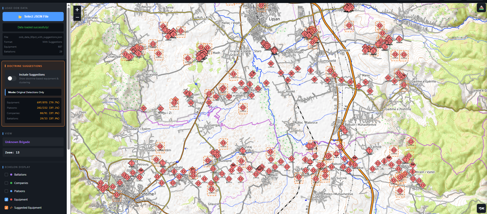
Analysts review suggestions, assess confidence, and approve inclusion. Unit boundaries automatically adjust upon approval.
Capabilities
What RedClear Delivers
Order of Battle Reconstruction
Automatically clusters detected equipment into platoons, companies, and battalions based on doctrinal templates. No manual correlation required.
Multi-Sensor Fusion
Combines data from any sensor source into a single unified intelligence layer regardless of format or origin.
Real-Time Force Composition
Identifies enemy unit types, equipment counts, and organizational structure as data arrives. Assessments update continuously.
Terrain-Integrated Intelligence
Overlays terrain analysis including elevation, slope, obstacles, and water bodies onto force disposition for complete operational context.
Formation Feature Extraction
Detects formation orientation, dimensions, zone boundaries, frontage and spacing, and classifies formations as offensive or defensive postures.
Course of Action Support
Provides the intelligence foundation for COA development by delivering structured force analysis that feeds directly into planning workflows.
Deployment
Designed to Meet Units Where They Are
Standalone Platform
A complete IPOE capability for units that need immediate battlefield intelligence without major infrastructure changes. Deploy and operate independently.
Integrated Module
Plugs into existing intelligence platforms and command systems to enhance, not replace, current workflows. Compatible with Programs of Record including Palantir and DCGS-A.
See RedClear in Action
Request a demo to see how RedClear transforms sensor observations into decision-ready battlefield intelligence.
Request a Demo